- Another round of snow is ahead from Missouri to Maine Into Monday.
- The heaviest snow could fall from Pennsylvania to Massachusetts.
- Not much ice is expected this go around.
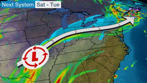
Just as Winter Storm John begins to pull out of the Northeast, another snowmaker is brewing in the Central U.S. This quicker-moving system will bring snow to communities in the Midwest that saw ice in recent days and add to the snowpack in the Northeast.
This new system will follow a similar trek through the Midwest and Northeast, but will generally bring colder air. This system will not have the ice threat that John brought to Missouri and Illinois despite tracking through both states.

Winter weather advisories are in effect from Pennsylvania to southern New England, including Harrisburg, Pennsylvania and Hartford, Connecticut. This area is where slippery roads are most likely.
Snow is already falling in parts of Kansas, Oklahoma and into the Ozarks. Snow will become more widespread today as the low pressure system moves into the Ohio Valley.

Current Radar
By late tonight, the mature low pressure system will bring snow from Missouri to the southern Great Lakes. Snow or a rain/snow mix will spread into the interior Northeast toward sunrise.
On Sunday, snow should stretch from southern Michigan and northern Ohio eastward to near the I-95 corridor, including the New York City area. This snowfall should be generally light to moderate in nature and could be mixed with rain along the I-76 corridor in Pennsylvania and along and east of the I-95 corridor between Philadelphia and Boston.
Scattered showers and a few storms are possible in the coastal Carolinas to Maryland and New Jersey.
New York City and Boston should remain plain rain for much of the day, but some snow may mix in at times. Boston may change over to snow late in the evening or during the overnight hours into Monday.
By Sunday night, snow will persist from the northern and central Appalachians into much of New England. Rain will end from Baltimore south during the evening hours, but will continue from Philadelphia to Cape Cod, slowly ending from south to north.

Sunday Night's Forecast
Some flurries will continue on Monday in coastal New England, possibly coming to an end Monday night.
Some computer guidance, though, suggests that this low pressure system may get stuck south of Maine or Nova Scotia into midweek, which would cause snow to stick around longer than currently forecasted.
(MORE: Weekly Planner)
Stay tuned.
Forecast Snowfall Totals
For most from Missouri to northern New England, snowfall totals will be light – generally less than three inches.
Heavier snow is likely from Pennsylvania's Pocono Mountains eastward to southern New England.
Snowfall gradients in some of the larger cities from Boston to Providence may be up to 5 inches, with coastal locations seeing an inch or two of snow (or less) and inland locations seeing substantially more snow. In New York City, little to no snow accumulations are anticipated, but more than three inches of snow may fall not too far north in the Hudson Valley.

The Weather Company’s primary journalistic mission is to report on breaking weather news, the environment and the importance of science to our lives. This story does not necessarily represent the position of our parent company, IBM.
"and" - Google News
January 03, 2021 at 08:44AM
https://ift.tt/3rRHsEu
Quick Shot of Snow Ahead for the Midwest and Northeast | The Weather Channel - Articles from The Weather Channel | weather.com - The Weather Channel
"and" - Google News
https://ift.tt/35sHtDV
https://ift.tt/2ycZSIP
And
Bagikan Berita Ini


0 Response to "Quick Shot of Snow Ahead for the Midwest and Northeast | The Weather Channel - Articles from The Weather Channel | weather.com - The Weather Channel"
Post a Comment