(CNN)[Breaking news update, published at 2:10 p.m. ET]
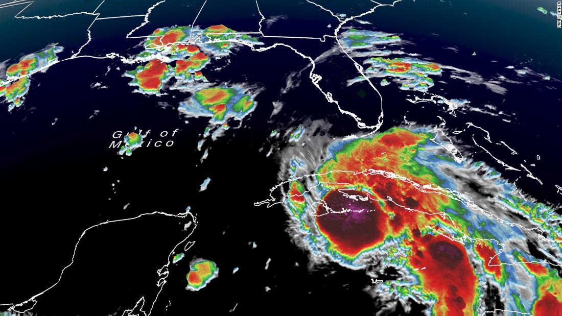
Hurricane Ida made landfall Friday afternoon on Cuba's Isle of Youth with sustained winds of 75 mph.
[Original story, published at 1:43 p.m. ET}
Ida became a hurricane Friday afternoon as it swept toward western Cuba -- and it's expected to strengthen into a major hurricane as it approaches the US Gulf Coast this weekend, putting states from Louisiana to Florida on alert for fierce destruction.
Mandatory and voluntary evacuation alerts were popping up Friday along parts of the Gulf Coast -- including parts of Louisiana and Mississippi in anticipation of Sunday's landfall.
In New Orleans, Mayor LaToya Cantrell issued a mandatory evacuation of all city areas that are outside the its levee protection system.
"We are activating every single resource at our disposal, so that we are prepared to respond," Cantrell said Friday.
If Ida makes landfall in Louisiana, it would be the fourth hurricane to do so since last August -- and would be Louisiana's third major hurricane landfall in that span.
Ida, which formed in Caribbean as a tropical storm Thursday, is expected to cross western Cuba on Friday as a hurricane and could cause life-threatening flash floods there and the Cayman Islands.
After that, rapid intensification of the storm is possible in the Gulf of Mexico, where Ida is expected to be a major hurricane -- defined as Category 3 or greater -- by the time it approaches the US Gulf Coast on Sunday.
Ida currently is forecast to make US landfall on Sunday evening -- 16 years to the day that Hurricane Katrina made landfall in Louisiana.
The possibility of major hurricane strength "should get your immediate attention," CNN meteorologist Chad Myers said Friday.
"Wind damage and storm surge will be life-threatening from Louisiana to the Florida Gulf Coast. Residents should also prepare for long-duration power outages," Myers said.
A Category 3 hurricane would bring sustained winds of at least 111 mph -- enough for major damage to even well-built homes.
Louisiana Gov. John Bel Edwards declared an emergency Thursday in anticipation of the storm.
"Unfortunately, all of Louisiana's coastline is currently in the forecast cone" for the storm, Edwards said. "Now is the time for people to finalize their emergency game plan, which should take into account the ongoing Covid-19 pandemic.
"By Saturday evening, everyone should be in the location where they intend to ride out the storm," he said.
Ida hitting Cuba and the Cayman Islands on Friday
Before it heads to the Gulf, Ida was poised to deliver dangerous amounts of rain to Cuba and the Cayman Islands, the National Hurricane Center said.
As of 1:15 p.m. ET Friday, Ida's center was in the Caribbean, heading toward western Cuba with sustained winds of 75 mph.
Ida could deliver 8 to 20 inches of rain in the Cayman Islands and western Cuba, including the Isle of Youth, hurricane center forecasters said.
"These rainfall amounts may produce life-threatening flash floods and mudslides," the hurricane center said.
Ida is expected to pass over western Cuba on Friday, and move into the southeastern and central Gulf of Mexico Friday night and Saturday.
Rapid intensification could happen in the Gulf. It would mean the storm's maximum sustained winds will have increased at least 35 mph in 24 hours or less. That's a jump of about two categories on the Saffir-Simpson scale, which grades hurricane strength from 1 to 5, the latter being the most intense.
Dangerous storm surge, winds and rain possible for US Gulf Coast
Once past Cuba, Ida is forecast to strengthen over the Gulf on Saturday and Sunday, and to be at major hurricane strength on Sunday before it smacks into some part of the US northern Gulf Coast, forecasters said.
Winds, storm surge and heavy rain are expected to be major threats.
"Potentially devastating wind damage could occur where the core of Ida moves onshore," the hurricane center said Friday.
As for storm surge: Water 7 to 11 feet above ground could move ashore if surge and high tide combine in an area from Morgan City, Louisiana, to Ocean Springs, Mississippi, the hurricane center said.
About 8 to 20 inches of rain are possible from southeast Louisiana to coastal Mississippi and Alabama through Monday morning, the hurricane center said.
After landfall, it could turn northeast as it moves inland. About 4 to 8 inches are possible across southern and central Mississippi, the hurricane center said.
"This is likely to result in considerable flash, urban, small stream, and riverine flooding," the hurricane center said.
A hurricane watch was in effect Friday for these parts of the US: Cameron, Louisiana, to the Mississippi-Alabama state line; metropolitan New Orleans; and Lake Pontchartrain and Lake Maurepas.
A storm surge watch was issued Friday for Sabine Pass, Texas, to the Alabama-Florida state line.
Two major hurricanes struck the US last year, both with landfalls in Louisiana: Laura as a Category 4 in August, and Zeta as a Category 3 in October. Zeta initially was thought to be a Category 2 storm when it hit, but a subsequent data review showed that it was Category 3 strength at landfall.
The last storm to undergo rapid intensification was Hurricane Grace last week before it hit Mexico.
"and" - Google News
August 28, 2021 at 01:14AM
https://ift.tt/2Y5WWu9
Hurricane Ida hits Cuba, and parts of US Gulf Coast order evacuations with major Sunday landfall expected - CNN
"and" - Google News
https://ift.tt/35sHtDV
https://ift.tt/2ycZSIP
And
Bagikan Berita Ini


0 Response to "Hurricane Ida hits Cuba, and parts of US Gulf Coast order evacuations with major Sunday landfall expected - CNN"
Post a Comment